Description
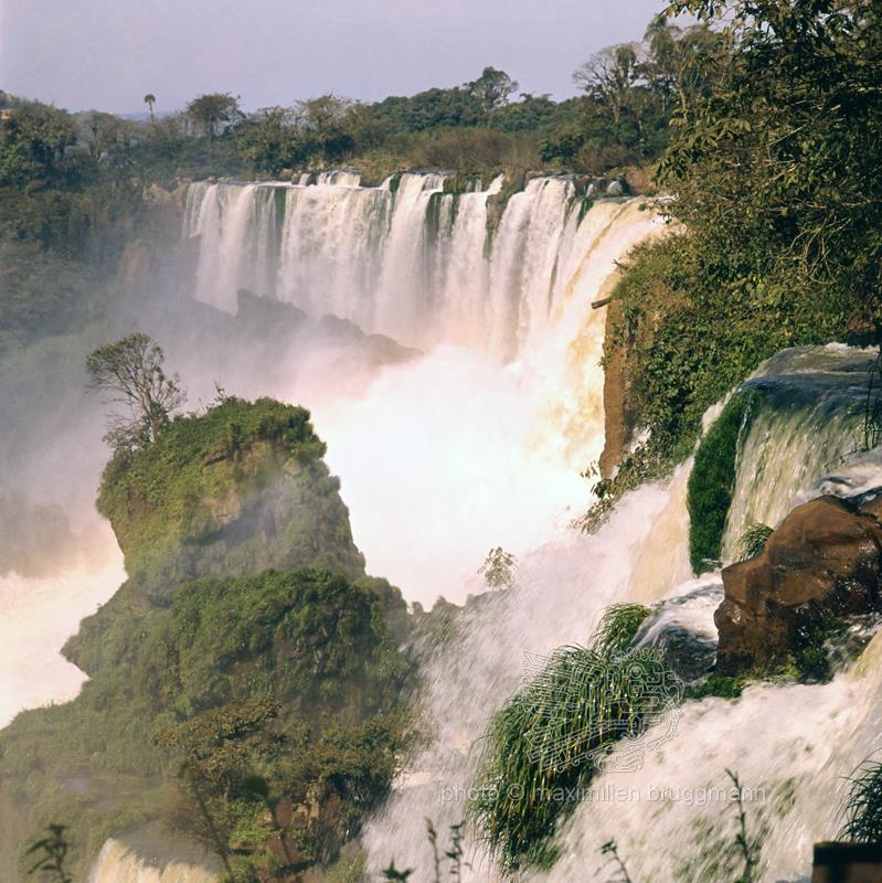
The water network in Argentina is widely ramified. Large rivers run through the country. Most of them have their source in the Andes Cordillera. At times they flood, especially during the southern summer, when the rain pours down almost incessantly on the heights of the Sierra. From the eastern foot of the Andes to the coastal strip of the Atlantic Ocean stretches a wide plain with a very slight gradient. Here, the watercourses meander lazily before pouring into the sea. On its banks, humans found a home and could devote himself to agriculture. These conditions apply primarily to the southern provinces. In the north, on the other hand, the climate is characterised by frequent rainfall, which causes rivers and streams to swell. Many waterways are navigable and play a not insignificant role in transport. The vegetation is tropical, with an endless variety of plants, some of which are used industrially. The landscape exerts a great fascination on all travellers who pass through this area. Here they will also find a natural wonder: the world-famous lguassú Falls in the heart of the jungle, in the extreme north of the province of Misiones. They plunge 70 metres in no less than two hundred and seventy-five waterfalls forming a three-kilometre-long arc. The source of the lguassú is in Brazil. - 1973
Description
The water network in Argentina is widely ramified. Large rivers run through the country. Most of them have their source in the Andes Cordillera. At times they flood, especially during the southern summer, when the rain pours down almost incessantly on the heights of the Sierra. From the eastern foot of the Andes to the coastal strip of the Atlantic Ocean stretches a wide plain with a very slight gradient. Here, the watercourses meander lazily before pouring into the sea. On its banks, humans found a home and could devote himself to agriculture. These conditions apply primarily to the southern provinces. In the north, on the other hand, the climate is characterised by frequent rainfall, which causes rivers and streams to swell. Many waterways are navigable and play a not insignificant role in transport. The vegetation is tropical, with an endless variety of plants, some of which are used industrially. The landscape exerts a great fascination on all travellers who pass through this area. Here they will also find a natural wonder: the world-famous lguassú Falls in the heart of the jungle, in the extreme north of the province of Misiones. They plunge 70 metres in no less than two hundred and seventy-five waterfalls forming a three-kilometre-long arc. The source of the lguassú is in Brazil. - 1973